Cameron La Follette
Cameron La Follette is the executive director of Oregon Coast Alliance, a nonprofit coastal conservation organization. Her publications include Sustainability and the Rights of Nature: An Introduction (CRC Press, 2017) and Sustainability and the Rights of Nature in Practice (CRC Press, 2019). Cameron is also a traditional poet whose work is archived by the University of Oregon Special Collections and University Archives. She is the lead researcher and author on most of the articles in a special issue of the Oregon Historical Quarterly on “Oregon’s Manila Galleon,” (Summer 2018), which explores the identity of the Spanish galleon that wrecked on Nehalem Spit.
Author's Entries
-
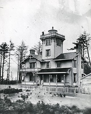
Cape Arago Lighthouse
The Cape Arago Lighthouse sits on a small island off Cape Arago, south of the entrance to Coos Bay and separated from the mainland by a narrow, rocky channel. Decommissioned in 2006, the lighthouse and island are owned by the Confederated Tribes of Coos, Lower Umpqua, and Siuslaw Indians. Completed …
Oregon Encyclopedia
-
Cape Lookout
Cape Lookout, one of the most prominent landmarks on the Oregon Coast, is a long, narrow promontory of rugged basalt that stretches over a mile and a half into the Pacific Ocean, approximately ten miles southwest of Tillamook. The cape is remarkable for its long oceanward reach and sheer cliffs …
Oregon Encyclopedia
-
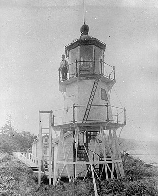
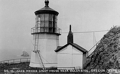
Cape Meares Lighthouse
Cape Meares Lighthouse is located atop Cape Meares, a scenic craggy headland about ten miles southwest of Tillamook Bay, where sheer cliffs drop some three hundred feet to the waters below. Both the lighthouse and the headland are named for British explorer and fur trader John Meares, who sailed along …
Oregon Encyclopedia
-
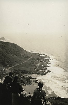
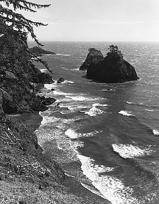
Cape Perpetua
Cape Perpetua juts into the Pacific Ocean about two miles south of Yachats on the central Oregon Coast in Lincoln County. Captain James Cook—who viewed the cape from the sea, but never set foot on it—bestowed its present name on March 7, 1778, to honor Saint Perpetua on her …
Oregon Encyclopedia
-
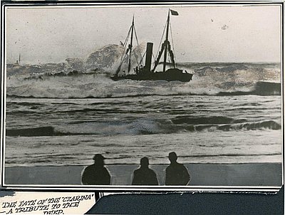
Czarina
The wreck of the Czarina is remembered as a tragedy that had no heroes, no villains, and no hope. The iron-hulled steamship, which weighed 1,045 tons and was 216 feet long, was built in England in 1883 and owned by Southern Pacific Company of San Francisco. When it wrecked on …
Oregon Encyclopedia
-
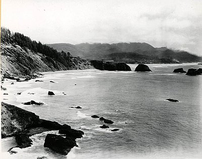
Ecola State Park
Ecola State Park stretches for 1,023 acres from the north end of Cannon Beach to Seaside on Oregon’s north coast. The park encompasses hulking Tillamook Head, which rises over a thousand feet above the ocean, and miles of beaches, smaller headlands, coves, and iconic sea stacks. The rugged shoreline of …
Oregon Encyclopedia
-
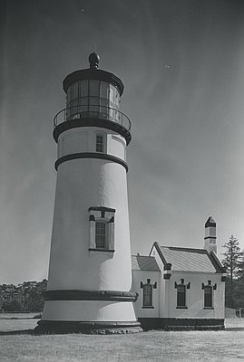
Heceta Head Lighthouse
Heceta Head Lighthouse stands 205 feet above the Pacific Ocean on a bluff carved out of the west side of 1,000-foot-high Heceta Head, twelve miles north of Florence. The light shining from the 56-foot-high tower flashes a white beam for eight seconds every minute. Visible for twenty-one miles, it remains …
Oregon Encyclopedia
-
Konapee wreck
The possible wreck of a European ship at Point Adams, on the southern edge of the Columbia River estuary, has long fascinated Oregonians. The ship—known as the “Konapee wreck” from the purported name of a survivor, as given by Clatsop and Chinook tradition-bearers—may have run aground before first recorded European …
Oregon Encyclopedia
-
Lakeport
Lakeport, for a brief time the largest town in Curry County, was located on Floras Lake, a 236-acre freshwater lake on the Oregon Coast ten miles north of Port Orford. The town had a dramatic rise and fall in the early twentieth century, when the adroit boosterism of Lakeport’s potential …
Oregon Encyclopedia
-
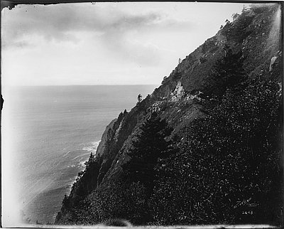
Neahkahnie Mountain
Neahkahnie Mountain, about twenty miles south of Seaside, is a prominent landmark in Oregon Coast geography, history, and lore. Standing 1,680 feet high, the basalt edifice is both a peak and a headland. Formed by Miocene lava flows surging down the ancestral Columbia River channel roughly 15 million years ago, …
Oregon Encyclopedia
-
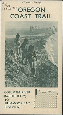
Oregon Coast Trail
Winding for 382 miles along the Oregon Coast, the Oregon Coast Trail is the most extensive and popular recreational trail built and maintained by the State of Oregon. The Coast Trail consists in part of formally designated and maintained trails over majestic headlands, often cutting a narrow swath through otherwise …
Oregon Encyclopedia
-
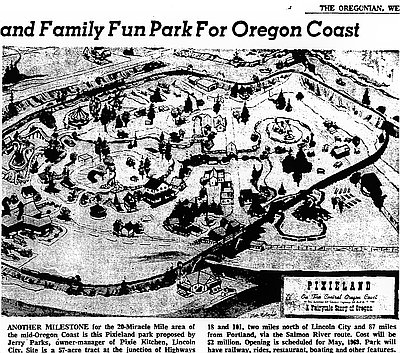
Pixieland
Pixieland was a short-lived but popular amusement park on the Oregon Coast northeast of Lincoln City, between the Salmon River and Highway 18. The park, which operated from 1969 to 1975, was a major regional tourist attraction known for its colorful décor, fun rides, and other amusements that catered to …
Oregon Encyclopedia
-
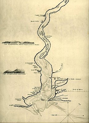
Point Adams
Located at the mouth of the Columbia River and marking the extreme northwestern corner of Oregon, Point Adams is a pivotal landmark in the geography and history of the state. For the Clatsop people, this was the site of the prominent village, Klaát-sop, for which their nation was named. The …
Oregon Encyclopedia
-
Point Adams Lighthouse and Life-Saving Station
Point Adams was given its name by Captain Robert Gray, who in his official log entry on May 19, 1792, named the spit of land Adam’s Point. Captain George Vancouver, later that year, referred to it as Point Adams, and the United States Exploring Expedition adopted that version …
Oregon Encyclopedia
-
Samuel H. Boardman State Park
The Samuel H. Boardman State Park is a 1,471-acre, 11-mile, linear park consisting of a stunning swath of coastal Curry County. Stretching west of Highway 101 in a continuous corridor from Brookings north to Pistol River State Park, Boardman State Park (now administratively referred to as a State Scenic Corridor) …
Oregon Encyclopedia
-
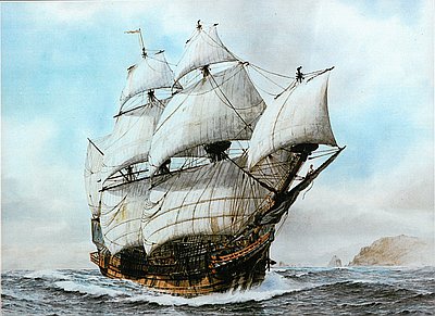
Santo Cristo de Burgos: An Essay
The Manila Galleon Trade and the Wreck on the Oregon Coast Nehalem-Tillamook and Clatsop peoples, and later EuroAmerican explorers and settlers of what is now Oregon’s north coast, knew that a large ship had wrecked on Nehalem Spit long ago. Archaeological and geological analysis has determined that it was …
Oregon Encyclopedia
-
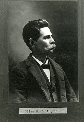
Silas Bryant Smith (1839-1902)
Silas Bryant Smith played a key role in recording the traditions, religions, and customs of the Clatsop people in nineteenth-century Oregon. A prominent historian of the region, he successfully bridged the two traditions, Clatsop and EuroAmerican, that he inherited from his parents. He also won the first Native land claims …
Oregon Encyclopedia
-
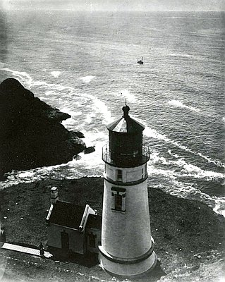
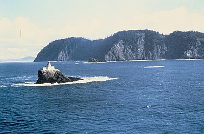
Tillamook Rock Lighthouse
Tillamook Rock Lighthouse sits on a rock a mile offshore of Tillamook Head in Clatsop County, Oregon. Operating from 1881 to 1957, the lighthouse was nicknamed Terrible Tilly for its ferocious storms and the difficulties facing lighthouse keepers stationed there. It was the most expensive lighthouse built in the United …
Oregon Encyclopedia
-
Umpqua River Lighthouse
The Umpqua River Lighthouse, Oregon’s first, was built twice. The U.S. Office of Coast Survey in 1849 selected the mouth of the Umpqua River as one of the first sixteen lighthouse locations for the West Coast. The survey sought to identify locations for a string of lighthouses detectible to mariners …
Oregon Encyclopedia
-
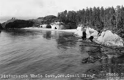
Whale Cove
Whale Cove is a small, nonnavigable bay in Lincoln County, approximately a mile and a half south of the town of Depoe Bay. Only about one-third of a mile in diameter, the cove is not mentioned by official coastal pilot guides as a place of refuge for any size vessel. …
Oregon Encyclopedia
-
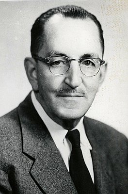
William M. Tugman (1894-1961)
William M. Tugman played a major role in the history of Oregon as an editor for the Eugene Register-Guard and the Port Umpqua Courier and as an advocate for Oregon state parks. His influence was especially strong in raising journalism standards in the state and in his tenure as chair …
Oregon Encyclopedia
-
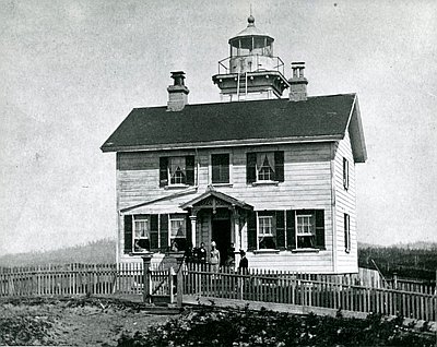
Yaquina Bay Lighthouse
Yaquina Bay Lighthouse, built in 1871, is the only wooden lighthouse in Oregon and is believed to be the oldest structure in Newport. The lighthouse was decommissioned in 1874. In February 1869, the Oregon legislature sent a memorial to the U.S. Senate petitioning for a lighthouse at the mouth of …
Oregon Encyclopedia
-
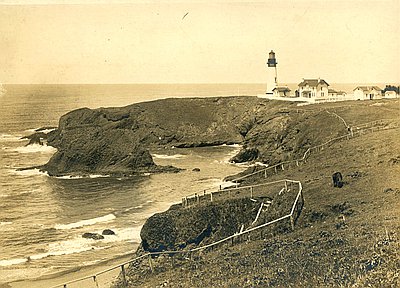
Yaquina Head Lighthouse
The U.S. Lighthouse Board built Yaquina Head Lighthouse in 1872 on Yaquina Head, a narrow peninsula of Columbia basalt that juts nearly a mile out to sea, about three miles north of Newport. The headland is within the traditional territories of the Yaquina people and was an important place for …
Oregon Encyclopedia